India needs to become an ambitious upstander, not a passive bystander, and engage proactively with an emerging geography of conflict and opportunity
To understand the ongoing political controversy around the Great Nicobar Project, referred to as India's “natural aircraft carrier” and “unsinkable carrier”, we need to reverse the gaze: from land to waters, and from development to security. The Great Nicobar Island is not merely a 1,045 sq. km. land mass. It is part of an island chain, the southernmost tip of India, that expands India's economic geography by 0.6 million sq. km. through the exclusive economic zone. To put this in perspective, the EEZ of the Andaman and Nicobar Islands is close to the combined size of Rajasthan and Madhya Pradesh; it is larger than the landmass of Ukraine, France, or Spain.
Just 40 nautical miles or 74 km from the Malacca Strait — roughly the distance between Kohima and Dimapur, or Amsterdam and Rotterdam — the Great Nicobar Island has been a bystander, silently watching 30 percent of global trade pass through a waterway that is just 2.5 km at its narrowest. About 29 percent of total maritime oil flows through this strait, of which crude comprises 70 percent and petroleum products the remainder. The Malacca Strait is the shortest sea route between oil and gas producers in West Asia and fast-growing consumers in East and Southeast Asia, including China, which accounts for 48 percent of import volumes through the Strait.
Malacca is becoming increasingly crucial to India too. At a time when energy chokepoints are being weaponised — as seen with the US and Iran at the Strait of Hormuz — there are important lessons for India regarding the Malacca Strait. It is a crucial chokepoint for India's goods exports to East and Southeast Asia and for oil imports from Russia. The Strait cannot, and must not, be weaponised against India. A strategic deterrent is needed to secure India's energy inflows and export outflows. On the northern end sits the Andaman and Nicobar Command (ANC); its expansion into Great Nicobar would extend cover across the entire 780 km. island chain — approximately the distance between New Delhi and Varanasi.
The southernmost node of this strategic deterrence is the Great Nicobar Project. To read this project solely through the lens of India's political economy would be an error. From Narmada to Niyamgiri to Nandigram, the politics of protest has stood firm — sometimes winning, as in West Bengal's Nandigram and Odisha's Niyamgiri; sometimes losing, as in Gujarat's Narmada or Tamil Nadu's Kudankulam. The central issues have been displacement and rehabilitation, pricing and compensation, and the roles of NGOs and opposition parties.
The protest playbook of the last century has no meaning, either in the volatile 21st century or in the Bay of Bengal. The toolkit is now predictable: a project is announced, maps are drawn, inaugurations by ministers are organised, money is budgeted, work begins — and then protests erupt. The argument that has haunted India since its first Prime Minister, Jawaharlal Nehru, termed dams the “temples of modern India” resumes.
The protest politics of the past, which ignited legitimate debates around development and displacement, must today be situated within a broader context, where governments across the world, India included, are navigating a series of volatile geopolitics. Security, as the overarching and fast-evolving variable, demands that these debates evolve too.
From the Chipko movement of the mid-1970s through the Narmada Bachao Andolan of the mid-1980s and the Kudankulam nuclear plant protests of the early 2010s, the need to build infrastructure has clashed with competitive politics and NGOs driven by a range of ideological and funding interests. Even private enterprises that could help secure resources or build globally competitive products have had to reverse course — as in the Niyamgiri protests or Jagatsinghpur.
The Sardar Sarovar Dam in Gujarat on the river Narmada provides water to more than 9,000 villages, though resettlement continues to this day. The Niyamgiri hills in Odisha saw 1,453 Dongria Kondh tribals reject Vedanta's bauxite mining in 2013, and the case has become a touchstone in the development versus status quo debate. The Singur and Nandigram protests, over the Tata Nano plant and the Salim Group's SEZ respectively, became defining grievances that contributed to the Left Front's defeat in the 2011 West Bengal assembly elections, ending 34 years of Communist rule in the state. The proposed steel plant of South Korea’s POSCO at Jagatsinghpur in Odisha collapsed in 2017, nearly a decade after resistance by communities whose betel vine livelihoods stood in its path; the project is now set to return.
Each time, India's economic ambitions have run up against its politics, producing the same irresolution: the people’s developmental ambitions colliding with the incumbents’ refusal to make space. The meaning of “development” has been stretched beyond recognition, one reading for the elected executive, another for NGOs and the opposition, and a third for the judiciary. Layered above all of this are cultural narratives, such as the Avatar comparison that surfaced during the Niyamgiri protests.
The Great Nicobar Project changes this vocabulary of engagement. At stake are energy security, trade routes, strategic deterrence, and a larger role in the region. Here, the country’s flexible political economy meets an uncompromisable strategic imperative. The protest politics of the past, which ignited legitimate debates around development and displacement, must today be situated within a broader context, where governments across the world, India included, are navigating a series of volatile geopolitics. Security, as the overarching and fast-evolving variable, demands that these debates evolve too.
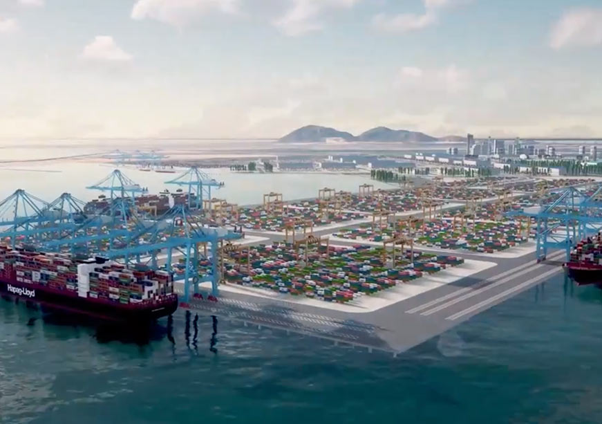
Development through ports, airports, and other infrastructure will not merely facilitate trade; the potential to become a major tourist and living destination, like Singapore, is incidental. The primary driver will be defence, which will build military infrastructure and establish a strategic presence. The US Indo-Pacific Command, headquartered in Honolulu, which has navigated environmental sensitivities in its area of operations, could offer a useful model. The Great Nicobar Island will primarily be a maritime and strategic hub, around which trade, tourism, and education could flourish.
The legal mechanisms for land acquisition in India are many and complex. Including the Jammu and Kashmir Requisitioning and Acquisition of Immovable Property Act, 1968, there are sixteen laws of land acquisition, three of them part of India’s colonial inheritance. This is aside from three military-related laws: the Works of Defence Act, 1903; the Defence of India Act, 1971; and the Cantonments Act, 2006. The Right to Fair Compensation and Transparency in Land Acquisition, Rehabilitation and Resettlement Act, 2013 applies to all but defence laws, overseeing the transition of land and ensuring financial protections.
The interests of the tribal communities living on the island — the 237 Shompens, who are hunter-gatherers, and the 1,094 fishing-dependent Nicobarese — are a central consideration in the project’s design. The government has stated that no community will be adversely affected and that no displacement of tribal people will be permitted. The land-use framework described below is intended to give effect to those commitments.
Of the total landmass of the Great Nicobar Island, 751.07 sq. km. is officially marked as tribal reserve. The Great Nicobar Project will occupy 166.10 sq. km. of the total land. Of this, 84.10 sq. km., or about half, overlaps with the tribal reserve. Within that overlap, 11.03 sq. km., or 13.1 percent, has been used as revenue land since 1972. The remaining 73.07 sq. km. is being de-notified for the project. Against this, 76.98 sq. km. is being re-notified as tribal reserve, a net addition of 3.91 sq. km.
What is needed is creative thinking that weaves modern urban settlements into the existing sea of green without unsettling the flora or displacing the tribal communities. Persuading those communities to become stakeholders in development is as important as the development itself.
While this framework attempts to balance development needs with tribal protections, questions remain about whether the land allocated will prove adequate for the project’s long-term ambitions. While such a compression may reflect the limitations and compromises inherent to democratic policymaking, it risks producing short-termism in planning. If the island is being envisaged as a major military, strategic, and commercial hub, its planning needs to look beyond decades into centuries. Allocating 166.10 sq. km. means the project area will be half the size of Frankfurt, a quarter of Chennai, and one-twelfth of New Delhi; it will be less than half the landholding of the Neyveli Lignite Corporation. The closest comparison is Honolulu’s 177.2 sq. km. (Urban Honolulu CDP), itself part of a chain of 137 islands and atolls stretching northwest to southeast, set against the 836 islands and islets of the Andaman and Nicobar chain running north to south.
These numbers provide not merely statistical contexts. They raise practical and operational concerns. Creating world-class infrastructure is a necessary condition for the project’s success, but it will not by itself be sufficient to attract world-class talent. Talent carries families, and families need schools, markets, universities, and hospitals. To expect top port professionals such as harbour masters, terminal managers, or port directors to relocate without their families would be a limiting vision. That model may work for a disciplined naval cohort, from midshipmen to admirals, who receive hard-area allowances; it will not work for civilians.
Being in Seismic Zone V, the highest in India, the island chain is vulnerable to earthquakes. But so are parts of Jammu and Kashmir, Himachal Pradesh, Uttarakhand, the Rann of Kutch in Gujarat, and parts of north Bihar, none of which have seen development stalled on seismic grounds. And so are thirteen other nations that rank higher than India in earthquake frequency, including Indonesia, Mexico, Japan, China, Argentina, and Greece, all of which continue to build, grow, and host hundreds of millions of people.
The proposed port, dual-use airport, township, and power plant at Great Nicobar Island could be one of India’s several answers to navigating a geopolitical environment that is, by any honest assessment, the most volatile since the end of the Cold War.
The answer to this geography of vulnerability is urban planning of resilience. If the terrain does not permit high-rise construction, the project will have to go horizontal, for which 166.10 sq. km. may not be adequate. Clearing the island’s dense forest cover, its five perennial rivers (Alexandra, Dogmar, Amrita Kaur, Jubilee, and Galathea) and its twenty-five freshwater streams would mean dismantling an ecosystem as vast and complex as it is delicate; that is not an option. What is needed is creative thinking that weaves modern urban settlements into the existing sea of green without unsettling the flora or displacing the tribal communities. Persuading those communities to become stakeholders in development is as important as the development itself.
Alternatively, the Great Nicobar project could serve as the southern anchor of a larger vision stretching from Landfall Island in the north, with several islands in between functioning as economic nodes under a defence umbrella. Most importantly, all should be connected through ferry services that serve as logistical and transportation arteries between the islands, while drawing tourist traffic from across the world. The project needs to think boldly on airports too — not one, not two, but five: two large ones at either end of the chain and three smaller ones in the middle. Apart from connectivity, such an arrangement will enable communities to access better healthcare, supplies, and intra-island engagements.
A new geopolitics is playing out, a new world order is in the making, a new strategic direction is being reimagined, and a stronger defence presence is building up in the region. From technology and finance to energy and chokepoints, everything is being used as a tool of power. And when everything is a weapon, everyone becomes a victim. The proposed port, dual-use airport, township, and power plant at Great Nicobar Island could be one of India’s several answers to navigating a geopolitical environment that is, by any honest assessment, the most volatile since the end of the Cold War. It could be a bulwark against the unchecked exercise of power, miscalculated ambitions driving wars with global consequences, and smaller nations becoming proxies in larger power struggles.
As in every country, when national security is at stake, it has always commanded a higher order of priority. India needs to reverse its gaze from land to waters, and from rights to security.
The concerns around forests and tribal communities are legitimate, and have run alongside every major project in India’s post-independence history, from Narmada to Nandigram to Niyamgiri. In Nicobar, however, these concerns must be weighed against a more urgent strategic imperative. It is equally true that India’s growth has been underlined with, and tested by, its democracy. But as in every country, when national security is at stake, it has always commanded a higher order of priority. India needs to reverse its gaze from land to waters, and from rights to security. The debates of the past may feed into, but no longer drive, the demands of the present that will influence the future.
The Great Nicobar Project must move forward at warp speed.
Gautam Chikermane is Vice President at the Observer Research Foundation.
The views expressed above belong to the author(s). ORF research and analyses now available on Telegram! Click here to access our curated content — blogs, longforms and interviews.

Gautam Chikermane is Vice President at Observer Research Foundation, New Delhi. His areas of research are grand strategy, economics, and foreign policy. He speaks to ...
Read More +